 Northern Region - Hwy 16
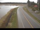
Masset
Highway 16 at Hodges Road in Masset on Haida Gwaii, looking north.
Tlell
Highway 16 at Wiggins Road on the east coast of Graham Island, looking north.
Skidegate
Highway 16 at the ferry terminal on Haida Gwaii, looking north.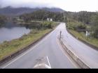
Port Edward - W
Highway 16 at Port Edward Arterial Road, looking west.
Port Edward - E
Highway 16 at Port Edward Arterial Road, looking east.
Port Edward - S
Highway 16 at Port Edward Arterial Road, looking south.
Rainbow Summit Chain-Up Area
Highway 16 about 34 km east of Prince Rupert near McNeil River at the Rainbow Summit chain-up area, looking west.
Kwinitsa
Highway 16 about 70 km east of Prince Rupert, looking east.
Kasiks
Highway 16 at Kasiks resort area about 60 km west of Terrace, looking east.
Terrace - W
Highway 16 at Highway 37S on the border of Terrace and Thornhill, looking west.
Terrace - E
Highway 16 at Highway 37S on the border of Terrace and Thornhill, looking east on Highway 16.
Terrace - S
Highway 16 at Highway 37S on the border of Terrace and Thornhill, looking south.
Chimdemash
Highway 16 near Chimdemash Creek about 22 km east of Highway 16 and Highway 37 junction in Terrace, looking north.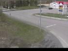
Kitwanga - N
Highway 16 at Highway 37 near Kitwanga, looking north on Highway 37.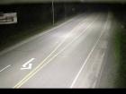
Kitwanga - W
Highway 16 at Highway 37 near Kitwanga, looking west on Highway 16.
Kitwanga - E
Highway 16 at Highway 37 near Kitwanga, looking east on Highway 16.
New Hazelton
Highway 16 at McLeod Street in New Hazelton, looking east.
Witset - N
Highway 16 at Beaver Road in Witset, looking north.
Witset - W
Highway 16 at Beaver Road in Witset, looking west.
Witset - S
Highway 16 at Beaver Road in Witset, looking south.
Trout Creek
Highway 16 at the Trout Creek bridge, looking southeast.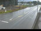
Hwy 16 at Toronto Street - N
Highway 16 at Toronto Street in Smithers, looking north.
Hwy 16 at Toronto Street - W
Highway 16 at Toronto Street in Smithers, looking west.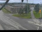
Hwy 16 at Toronto Street - E
Highway 16 at Toronto Street in Smithers, looking east.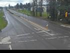
Hwy 16 at Toronto Street - S
Highway 16 at Toronto Street in Smithers, looking south.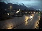
Smithers - N
Highway 16 at Main Street in Smithers, looking north.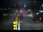
Smithers - W
Highway 16 at Main Street in Smithers, looking west.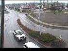
Smithers - E
Highway 16 at Main Street in Smithers, looking east.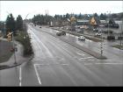
Smithers - S
Highway 16 at Main Street in Smithers, looking south.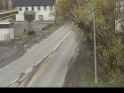
Telkwa - N
Highway 16 at Hankin Road in Telkwa, looking north.
Telkwa - E
Highway 16 at Hankin Road in Telkwa, looking east.
Telkwa - S
Highway 16 at Hankin Road in Telkwa, looking south
Hungry Hill - NW
Highway 16 about 14 km northwest of Houston at Anderson Road, looking northwest.
Hungry Hill - SE
Highway 16 about 14 km northwest of Houston at Anderson Road, looking southeast.
Nadina - N
Highway 16 at North Nadina Avenue in Houston, looking north.
Nadina - W
Highway 16 at North Nadina Avenue in Houston, looking west.
Nadina - E
Highway 16 at North Nadina Avenue in Houston, looking east.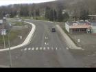
Butler - W
Highway 16 at Butler Avenue in Houston, looking west.
Butler - E
Highway 16 at Butler Avenue in Houston, looking east.
Six Mile Hill
Highway 16 about 39 km west of Burns Lake, looking west.
Burns Lake - W
Highway 16 at North Francois Highway in Burns Lake, looking west.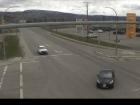
Burns Lake - E
Highway 16 at North Francois Highway in Burns Lake, looking east.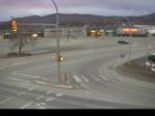
Burns Lake - S
Highway 16 at North Francois Highway in Burns Lake, looking south.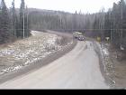
Augier Road - N
Highway 16 about 22 km east of Burns Lake at Augier Road, looking north.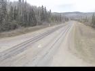
Augier Road - W
Highway 16 about 22 km east of Burns Lake at Augier Road, looking west.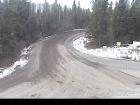
Augier Road - S
Highway 16 about 22 km east of Burns Lake at Augier Road, looking south.
Priestly Hill
Highway 16 about 32 km east of Burns Lake, looking east.
Savory Rest Area - W
Highway 16 about 46 km east of Burns Lake, looking west.
Savory Rest Area - E
Highway 16 about 46 km east of Burns Lake, looking east.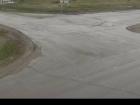
Stella Road - N
Highway 16 at Stella Road in Fraser Lake, looking north.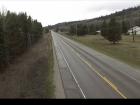
Stella Road - W
Highway 16 at Stella Road in Fraser Lake, looking west.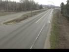
Stella Road - E
Highway 16 at Stella Road in Fraser Lake, looking east.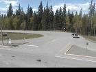
Nautley Road - N
Highway 16 at Nautley Road, looking north.
Nautley Road - W
Highway 16 at Nautley Road, looking west.
Nautley Road - E
Highway 16 at Nautley Road, looking east.
Fort Fraser Hills
Highway 16 about 5 km east of Fort Fraser, looking east.
Hwy 16 at Hwy 27 - N
Highway 16 at Highway 27 junction, looking north.
Hwy 16 at Hwy 27 - W
Highway 16 at Highway 27 junction, looking west.
Hwy 16 at Hwy 27 - E
Highway 16 at Highway 27 junction, looking east.
Sob Lake - W
Highway 16 at Sob Lake Road in Vanderhoof, looking west.
Sob Lake - E
Highway 16 at Sob Lake Road in Vanderhoof, looking east.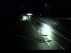
Bednesti Lake - W
Highway 16 at Bobtail Forest Road near Bednesti Lake between Prince George and Vanderhoof, looking west.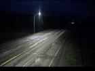
Bednesti Lake - E
Highway 16 at Bobtail Forest Road near Bednesti Lake between Prince George and Vanderhoof, looking east.
Tamarack
Highway 16 about 33 km west of Prince George, looking west.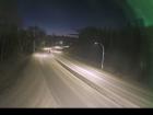
Peden Hill at Davis Road
Highway 16 at Davis Road in Prince George, looking eastbound.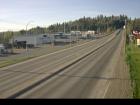
Peden Hill at Vance Road
Highway 16 at Vance Road in Prince George, looking westbound.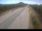
Bowron River
Highway 16 about 54 km east of Prince George near Purden Lake, looking west.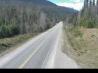
Slim Creek - W
Highway 16 about 0.4 km east of the Slim Creek Rest Area, looking west.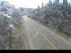
Slim Creek - E
Highway 16 about 0.4 km east of the Slim Creek Rest Area, looking east.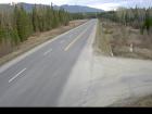
Crescent Spur
Highway 16 about 50 km west of McBride at Loos Road, looking west.
West Twin - W
Highway 16 at West Twin Creek, looking west.
West Twin - E
Highway 16 at West Twin Creek, looking east.
Dunster Station Road
Highway 16 at Dunster Station Road, about 30 km east of McBride, looking east.
Tete Jaune Cache
Highway 16 at Highway 5 junction, looking east.
Red Pass
Highway 16 about 27 km east of Tete-Jaune Junction and 40 km west of BC-Alberta border, looking east.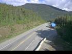
BC-Alberta Border
Highway 16 about 0.5 km west of the BC-Alberta border and 1 km to Jasper in Alberta, looking west.


